A Collection of Area Photos! - Page 2
(go to Photo Page 1, Photo Page 3, Photo Page 4)
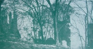 |
Stickley (Bowman) Mill Ruins. Midway between Middletown and Strasburg, Va. along Cedar Creek and the Shenandoah Valley Pike are two stone mill ruins. The smaller mill was operated when it had but two competitors in the Lower Shenandoah Valley. The larger was burned in October, 1864, when over 100 mills and 2000 barns and contents were destroyed and 15,000 domestic animals driven from the region by Union forces. This drastic action was to prevent the "Granary of the Confederacy" from maintaining another army, and General Sheridan boasted that a crow would have to carry his knapsack to cross the Valley. Published by Shenandoah Publishing House, Strasburg Virginia. |
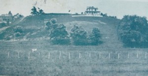 |
Banks' Fort, Strasburg, Virginia. When Gen. N. P. Banks was sent to the Shenandoah Valley in 1862 to prevent a Confederate movement upon Washington, he made Strasburg his headquarters so as to control the Manassas Gap Railroad (Southern) and the Valley Pike. He built an earthworks within the town, which commanded the entire Valley. The construction was watched from signal Knob and reported daily to Stonewall Jackson. No guns had been mounted when Banks was compelled to evacuate by Jackson's rapid flank movement via Page Valley and Winchester. The fort is one of the best preserved in the Valley. Published by Shenandoah Publishing House, Strasburg Virginia. Banks Fort has been improved with running water etc. in recent years. |
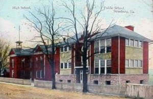 |
Picture of the old Strasburg High School built about 1912. The building in the left of the picture is the Strasburg Academy. The Strasburg Academy was built about 1808 and was demolished about 1926 and a new school house was then erected at that site. The construction of the Strasburg Academy was funded by Peter Stover, the founder of the Town of Strasburg |
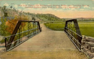 |
The Valley Pike looking north from the Tumbling Run Bridge at the foot of Fisher's Hill. This is the scene about one mile south of Strasburg looking north towards the town. The Shenandoah River is to the right but not visible in this picture. This bridge no longer stands at that site. |